Southern Utah’s Most Popular Hikes
Key Takeaways
- Hiking in Southern Utah is best known for Zion’s canyon hikes and Bryce Canyon’s surreal hoodoo landscapes.
- Angels Landing is one of the best Utah hikes for panoramic views, but it is steep and exposed.
- The Narrows is a unique Zion National Park hike in Utah where you walk through the Virgin River between towering canyon walls.
- Fairyland Loop is one of the best hiking trails in Utah for scenery-per-mile, with constant viewpoints in Bryce Canyon.
- Trail conditions, heat, and water levels can change quickly, so preparation matters for all hikes in Southern Utah.
Utah hiking is the kind of trip that ruins other places for a while. One day you’re hiking in Utah through a river slot canyon, the next you’re climbing switchbacks to a ridgeline view, and the next you’re walking between hoodoos that look like they belong on another planet. If you’re planning a Utah hiking trip and want a high-impact short list, these Southern Utah hikes are some of the most talked-about trails in Utah for good reason.
This guide covers three top hikes in Utah located in the Utah national parks that most visitors come for:
Zion National Park and Bryce Canyon National Park. If you only have time for a few Utah hikes, start here.
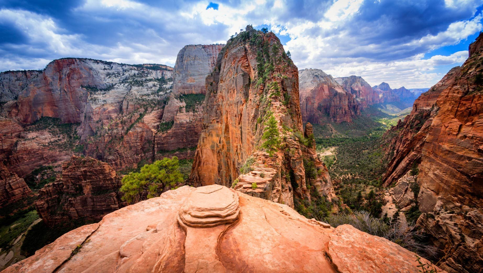
1) Angels Landing (Zion National Park)
If you search “best hikes Utah” or “Utah best hikes,” Angels Landing shows up almost every time. This is one of the most iconic Utah hiking trails in Zion National Park, and it’s famous for both the views and the exposure near the top.
Why it’s a top hike in Utah
Angels Landing is the type of Utah hike that feels like an achievement. You gain elevation fast, hit a legendary switchback section, and finish with a narrow ridge that leads to huge Zion Canyon views.
What the hike is like
The trail is about 2.4 miles (out-and-back) and climbs around 1,500 feet. You’ll climb up Walter’s Wiggles, take a breather at Scouts Lookout, then decide whether you want to continue onto the chain-assisted ridge. The final section is the part that makes this one of the most intense hikes in Southern Utah.
Tips for hikers
- Start early to avoid crowds and heat.
- Bring more water than you think you need.
- Wear grippy shoes and keep both hands free near the ridge.
- If heights are a deal-breaker, hike to Scouts Lookout for a safer version of the experience.
This is a Zion National Park hike in Utah that belongs on your list if you want one of the best hikes in Southern Utah with a true “summit moment.”
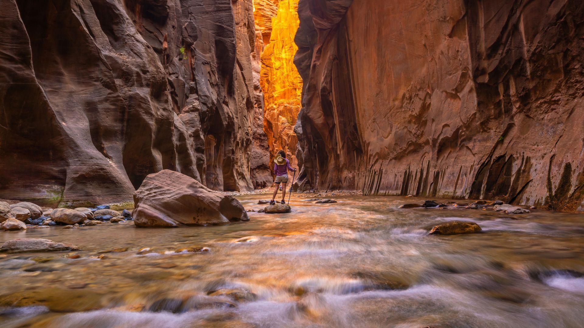
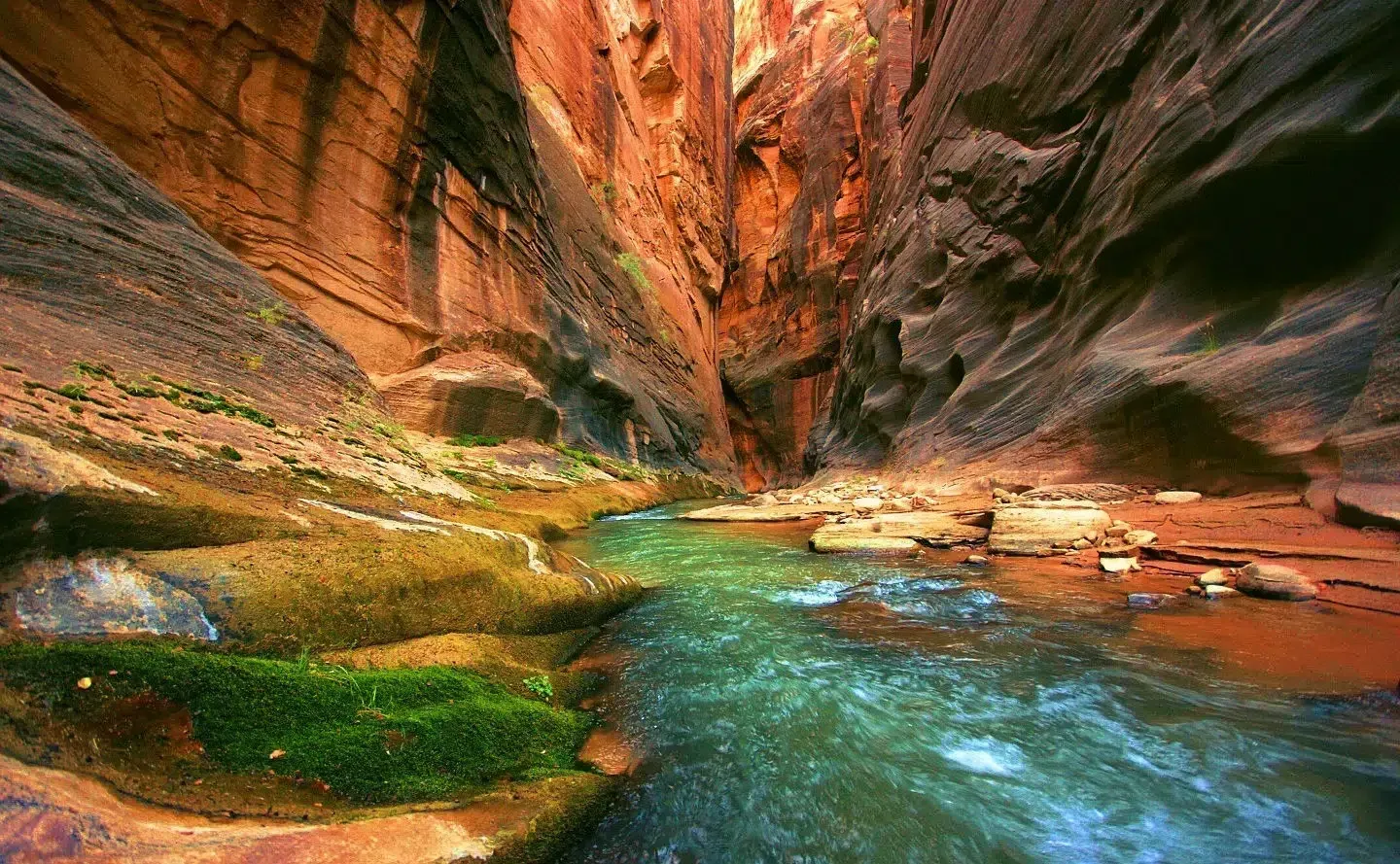
2) The Narrows (Zion National Park)
The Narrows is one of the most unique hiking trails in Utah because the trail is the river. You are literally hiking in Utah canyons while wading through the Virgin River, surrounded by towering walls and reflected light.
Why it’s one of the best hiking places in Utah
This is a choose-your-own adventure. Many hikers do a shorter out-and-back day hike, while experienced groups tackle the full route as a longer hike. Either way, The Narrows is easily one of the best hikes in Utah for unforgettable scenery.
Bottom-up day hike (most popular option)
Most visitors start at the Temple of Sinawava and hike upstream for as long as they want before turning back. That flexibility makes it a great option for people searching for good hikes in Utah that can be adjusted to different fitness levels.
Top-down route (advanced option)
For a bigger challenge, a top-down route is a longer traverse through the canyon. This is often associated with backpacking Southern Utah style trips, depending on how your group plans it.
Safety and planning
Because this is one of the most famous Utah canyon hikes, it draws a lot of people, but conditions matter more here than almost anywhere:
- Check weather and flash flood risk before you go.
- Check flow rates and water temperature.
- Use a walking stick or trekking poles for stability.
- Dry bag your essentials.
If you want “hiking Utah national parks” experiences that feel truly different from normal trails in Utah, this one is hard to beat.
3) Fairyland Loop (Bryce Canyon National Park)
Fairyland Loop is a standout if you want beautiful hikes in Utah that are scenic from start to finish. Bryce Canyon is smaller than Zion, but the scenery is dense, dramatic, and constant. If you’re building a list of the best hiking trails Utah travelers should do at least once, this loop belongs on it.
What makes it special
This 8-mile loop shows off Bryce’s signature hoodoos, amphitheater views, and surreal rock formations. You’ll see famous viewpoints like Fairyland Point and Sunrise Point, plus features like the Chinese Wall, which is one of the most photogenic sections of the route.
What to know before you go
- Plan for changing elevation and sun exposure.
- Bring plenty of water and snacks.
- Start early for parking and cooler temperatures.
For many visitors, this is one of the best places to hike in Utah if you want variety without needing technical skills.
Quick prep checklist for hiking in Southern Utah
Southern Utah hiking trails are stunning, but they’re not forgiving if you underestimate heat, exposure, or river conditions.
- Water: carry enough and start early
- Weather: check forecasts and trail alerts
- Footwear: grippy soles for Angels Landing, water-appropriate shoes for The Narrows
- Sun protection: hat, sunscreen, sunglasses
- Navigation: know your turnaround point
- Permits: some hikes may require permits depending on the route and current rules
If you want extra confidence,
interpretive hikes Utah local guides can be a solid option, especially for timing, conditions, and planning the safest route based on your group.
Frequently Asked Questions
Discover the most popular hikes in Southern Utah, including Angels Landing, The Narrows, and the Fairyland Loop — each offering unique views, challenges, and unforgettable scenery.
What are the most popular hikes in Southern Utah?
Southern Utah’s most famous hikes are Angels Landing and The Narrows in Zion National Park, and the Fairyland Loop in Bryce Canyon. Each offers stunning scenery, from towering canyon walls and rivers to hoodoos and panoramic vistas.
How difficult is the Angels Landing hike?
Angels Landing is a strenuous hike with steep switchbacks and a narrow ridge section featuring steep drop-offs. It’s about 2.4 miles long and climbs roughly 1,500 feet. While challenging, it rewards hikers with one of Zion National Park’s most breathtaking views.
What makes The Narrows hike unique?
The Narrows stands out because hikers walk directly through the Virgin River, surrounded by towering sandstone cliffs. The route can be a short day hike or a two-day backpacking trip from top to bottom. Checking water levels and weather is essential before starting.
Do I need a permit to hike in Southern Utah?
Some hikes, such as Angels Landing and the top-down route of The Narrows, require permits. Always check with the park’s visitor center before you go to ensure you have the proper permits and understand current conditions and restrictions.
When is the best time to hike in Southern Utah?
Spring and fall are the best seasons for hiking in Southern Utah, offering mild temperatures and stable weather. Summer can be extremely hot, while winter may bring snow or icy conditions to higher elevations like Bryce Canyon.
How long is The Fairyland Loop trail?
The Fairyland Loop in Bryce Canyon is about eight miles long. It offers varied terrain, elevation changes, and incredible viewpoints like Fairyland Point and Sunrise Point. It’s a moderately challenging hike with fewer crowds than other Bryce Canyon trails.
Are guided hikes available in Southern Utah?
Yes, many outfitters and guides offer hiking and backpacking tours throughout Southern Utah. Hiring a guide can help with permits, safety, and navigation while providing insight into the area’s geology, wildlife, and hidden gems.
What should I bring for hiking in Southern Utah?
Bring plenty of water, sturdy hiking shoes, sun protection, snacks, and a map or GPS. For hikes like The Narrows, waterproof shoes and trekking poles are highly recommended. Always check weather conditions before heading out.
Can you hike The Narrows year-round?
You can hike The Narrows most of the year, but conditions vary. Spring runoff and flash floods can make the trail dangerous or inaccessible. Always check river flow rates and weather forecasts before attempting the hike.
What safety precautions should hikers take?
Stay hydrated, wear appropriate footwear, and avoid hiking during storms or extreme heat. For narrow or exposed trails like Angels Landing, use caution and be aware of your footing. Always inform someone of your plans before you go.
Four Season Guides, 506 N Grant St suite o, Flagstaff, AZ 86004, United States
+19285251552
35.19653980, -111.62000560
Read More